
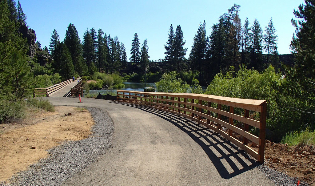
Path from Sunriver to Lava Lands [photo credit: Visit Central Oregon]
As the days get warmer and sunnier, we are enjoying seeing so many more folks out biking around town! The energy is palpable here at Bend Bikes and we have a lot of great projects coming down the pipeline.
Goal Setting for 2021 – 2022
We had our first meeting with our new full board and everyone hit the ground rolling with our goal setting for 2021 – 2022.
Transportation Bond Projects – The Transportation Bond Oversight Committee (TBOC) kicks off at the end of this month and we are ramping up to advocate to prioritize the projects that will allow people who walk, bike, and roll to see improvements on the ground as soon as possible. For those who want to dork out on the nitty gritty, start familiarizing yourselves with the City’s website for the GO Bond, the Transportation System Plan, and the TBOC.
East/West Connectivity – With funds anticipated from the transportation bond, ODOT, and neighborhood greenway funding, are seeing a lot of opportunities to improve East/West connectivity for people who bike, including Franklin, Greenwood, Hawthorne, and Olney.
Bend Bike Map – We have convened a work group of volunteers and board members with a lot of motivation and passion to make a Bend bike map a reality! We’re planning to keep the project simple to start so we can get something released, but hope to build on a solid foundation so we can enable community contributions to our map over time.
Community Outreach – After the amazing support for and success of the Neighborhood Street Safety Program (NSSP), we realized we could be collaborating with and supporting our neighborhood associations better. Are you a member of or active in your neighborhood association? Shoot us an email at [email protected] — we would love to connect with you this year when we ramp up our outreach efforts!
Lava Lands Paved Path – Call for Support!
The Sun Lava Trail is a multi-use path for pedestrians and bicyclists that connects Lava Lands to Sunriver, but users currently have no safe option to travel between Lava Lands and the city of Bend. The proposed 6.1-mile trail would link up the Baker/Knott Road interchange at Bend’s southern edge to the Lava Lands Visitor Center, providing a much-needed connection that would allow access to the Newberry Volcanic Monument and the High Desert Museum. ODOT projects that 80,000 people will be able to use the trail each year, so in addition to providing a safe, unique user experience for tourists and locals alike, it will help ease up car traffic along that stretch of highway.
After performing a few different studies, ODOT has determined that the safest way to build the trail will be in two parts: the northern part of the trail will run on the east side of U.S. 97 between Knott Road to an underpass near the High Desert Museum–there, the trail will split, and one section will continue to the High Desert Museum while the other leg will run under U.S. 97 and take users past the lava flow down to the Lava Lands Visitor Center, where it will link up to the Sun Lava Trail.
ODOT is providing an opportunity to review the project materials through a virtual open house which is online at the website: https://odotopenhouse.org/us97multiusetrailproject. Comments are due April 30th.
We encourage you to submit additional questions or voice more generalized support of this project to Rick Swart, ODOT Community Affairs Coordinator, at 541.388.6037 or [email protected]. The more support that we have for this project the better!
Climate-Friendly and Equitable Communities Rulemaking Effort Seeks Your Input!
The Department of Land Conservation and Development (DLCD) staff are convening a community conversation for residents of Bend on May 11, 2021 from noon – 1:30 pm via Zoom (register here)! Check out our last newsletter for more information about the rulemaking.
Some talking points for folks from our community partner 1000 Friends of Oregon:
- Invest in a network of connected, safe, and accessible sidewalk, paths, and bicycles ways, with the goal of increasing walking and bicycling trips to at least 50% of all trips.
- Reduce or eliminate off-street parking requirements.
- Improve transit service for people, through investments in transit signal priority, transit priority lanes, safe street crossings, better lighting at stops, etc.
- Public dollars from ODOT and DLCD should prioritize carrying out these climate-smart actions – no more pennies for pedestrians and billions for roads.
We want the DLCD to hear loud and clear:
- The time to act is now: Climate change is accelerating and adversely impacting the health and livelihoods of people who live in Bend and Central Oregon. The impacts fall disproportionately on Black and Indigenous people, communities of color, and lower-income people.
- While the DLCD’s desired outcomes are the right ones, the proposals so far from DLCD and its sister agency, ODOT, will not get us there. We should not keep doing what is not working.
- Share your personal story: Can you safely walk, bike, or take a bus from near your home to where you want to go? What will it take to allow you to do so? How does the DLCD serve people and not the movement of cars?
Bend Bikes Vision: Protected Bike Lanes
In our previous newsletters we’ve now discussed complete bike networks and what that means and levels of stress for people who bike and how that lends to a low stress bike network (part of being a complete bike network). Now we will look at different parts of a bike network and how they can make up a complete low stress bike network. So that leads us to protected bike lanes!
Protected bike lanes are a key element in a low stress bike network. ‘Protected’ means that the person who is biking is separated from motor vehicle traffic using a physical barrier – this could include planter boxes, plastic bollards, parked cars, and/or curbing (including a raised bike lane). This physical barrier increases comfort for people who are biking thus making the route lower stress.
In this example we see planter boxes and parked cars protecting the bike lane. This is a great example because the people on bikes are protected from car doors being opened by the planter boxes and have a lane of parked cars between them and moving car traffic.
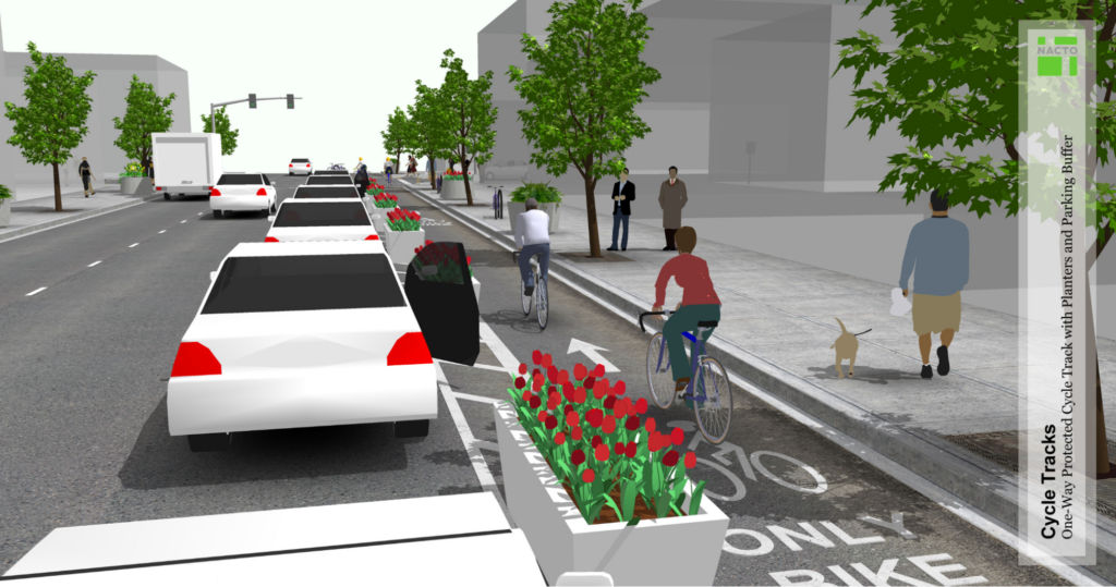
[Photo credit: NACTO]
Bend Bikes recommends a physical barrier that a car cannot drive over for the lowest level of stress in a bike lane. There are a few examples of protected bike lanes in Bend now. One is the curbed raised bike lane on Reed Market next to Farewell Bend Park, however a car could drive up onto this making it less than ideal.
Another example is the newly constructed bike lane in front of Crux on Division Street. This has plastic bollards to protect people while they are bicycling and is a great example of a low stress section of bike lane. Where else would you like to see a protected bike lane in Bend?