
City planning plays a critical yet fairly hidden role in shaping our lives. It influences everything from how far away the grocery store is to whether a road has a bike lane and many things in between.
It is especially important when it comes to biking and walking infrastructure – because new buildings and roads tend to be made for cars by default, and there need to be rules in place to counteract that car-first tendency. Things like street trees, parks, public art, and other things that make a city nice but cost money also need official rules to ensure they get built. Beautiful towns are more expensive to build and don’t happen by accident.
City planning is pretty complicated and can be hard to follow unless you have eons of spare time. We’re going to gather up the basic knowledge you need to be more informed about what is happening in Bend and how it’s happening – all from a biking and walking perspective.
We’ll build up this information over time – definitely let us know what we’re missing and if anything is still confusing!
Basic development process
Private development
All new private development in Bend goes through a public permitting process through Bend’s Planning Division. This means when a new house (or anything else) wants to get built, it must first submit an application to the city. The application is reviewed to make sure it follows all of the city standards, and if it does, it gets approved.
Because this is all public, there’s actually a live report of all the planning applications that are submitted each month. You can also search for these planning applications by address.
There are many different application types – but the ones that are of most interest to biking and walking are “Site Plans”. This type is used for new development, or large changes in existing developments. This often means that the roads in the development will need to be updated or that bike parking and car parking will be affected.
Planning application lifecycle
A specific project may start off with a “Pre-Application” which is an informal meeting where the applicant can ask the city any questions that might be helpful before starting the real planning process.
The real planning process then gets kicked off when an application is formally submitted, the status will then be “Pending Application”.
The city planners review the pending application to make sure all of the needed information was provided. Depending on the specific application they are looking for a layout for the proposed development (where the buildings and roads go), architectural renderings, landscape plans, traffic analysis, and things like that. If the application has all of the paperwork done, the nearby neighbors are notified and a public comment period starts (for ~14 days).
After the comment period closes, we hit a fork in the road depending on what’s being proposed:
- Large applications (like new neighborhoods) usually require a public hearing where people are invited to hear about the development in detail and can provide feedback. This feedback is considered by the planning department when reviewing the application. If the application is really large sometimes city council will even get involved – these are the projects you hear about in the news.
- If the development is small and is a “Permitted” use, that means it is always allowed to be built. So even if the public comment period had a ton of horrible feedback, if you want to build a single family home in an existing residential neighborhood, no one can really stop you as long as all of the rules are followed. Applications like these generally don’t have public hearings and instead get an “Administrative decision”. Minor changes to existing development also fall in this bucket.
- If the development is a “Conditional” use, that means it needs explicit approval in order to be built. It’s up to the planning department to decide whether they need a public hearing or not. It often depends on the comments received in that initial public comment period.
And after all of that public input and and double checking all of the city’s rules and standards, a decision is made.
The city made a nice chart of this whole process!
Public infrastructure
Public projects are a bit different than private ones. The new road projects in town don’t get submitted as applications to the planning department and don’t always follow the same rules that are required of private developments. When done right, this lets the city experiment with new road designs that could end up in future road standards that everyone else would have to follow.
These types of projects are listed on the city’s website. Most, but not all, have public comment periods that allow everyone to provide feedback.
Rules & Standards
Bend is a booming town, and our planning department sees a lot of action. This means that many of the new private developments don’t receive a lot of public input – and this is why the rules & standards are so important! A change in the rules (like requiring a wider sidewalk) will slowly spread on its own all throughout the city without costing Bend itself any money.
So what are Bend’s development rules?
There’s a searchable Bend Development Code and the city’s Standards and Specifications.
The code is more of a high-level document and refers to the standards for the nitty gritty details. They both matter for biking. The former might say “this road must use a collector design” and the latter describes exactly what a “collector” looks like.
Important terms and concepts
Objective rules and decisions
City planning revolves around applying a set of objective rules to all new developments. It’s very important that these rules are precise, written down, and consistently interpreted so that all new developments are held to the same standard.
So the rules that a city planner uses to decide whether a new development should be improved are critical. Change the rules and the entire city changes (albeit slowly, construction takes time!)
LTS • Level of Traffic Stress
LTS (Level of Traffic Stress) is an objective measure of how stressful a road feels to a biker or walker. Obviously stress levels vary between people and is usually a subjective thing – but subjective definitions are not very helpful in city planning (as described above!).
LTS tries to quantify exactly how good a bike lane is or when a street needs an improved crossing. Bend currently uses ODOT’s (Oregon Department of Transportation) definition of LTS. Bend Bikes thinks this definition could be better, but it’s what we have today.
Our current definition ranges from LTS 1 (low stress) to LTS 4 (high stress). LTS 1 is meant to be for all ages and abilities and is what we think all of the key routes in Bend should target today.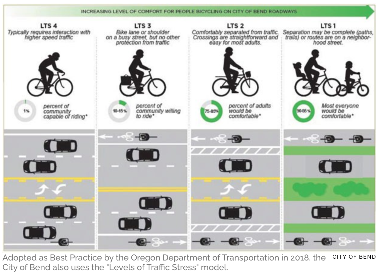
Sometimes you will also see BLTS to refer to stress for bicyclists and PLTS for walkers (pedestrians).
ADT • Average Daily Traffic
ADT (Average Daily Traffic) refers to how many cars a road sees per day. It’s used to decide how busy a road is, and thus what bike infrastructure is required (e.g. is a basic bike lane okay, or are there too many cars?)
The state measures ADT at various points around Bend (zoom in a lot, the website is slow!) but the data is usually a couple of years old.
The city also measures traffic data in a couple of different ways but their data is also usually quite old.
ODOT • Oregon Department of Transportation
ODOT (Oregon Department of Transportation) is responsible for transportation in Oregon. They do many things, but from Bend’s perspective the most important bit is that they do the maintenance and construction on our highways:
• Hwy 20 (including Greenwood)
• Hwy 97 (including portions of 3rd and interchanges/nearby street lights)
• Cascade Lakes Highway
Arterial, Collector and Local roads
All of the roads in Bend are assigned a type by the city. “Highways” are the largest roads followed by “Arterials”, then “Collectors” and then everything else is a “Local” road. Each road type has a specific design it must follow – a certain width, sidewalk size, bike lane treatment, etc.
These road designs can be found in the Roadway Standards (linked from the Standards page) and there’s a map of all the road types in Bend.